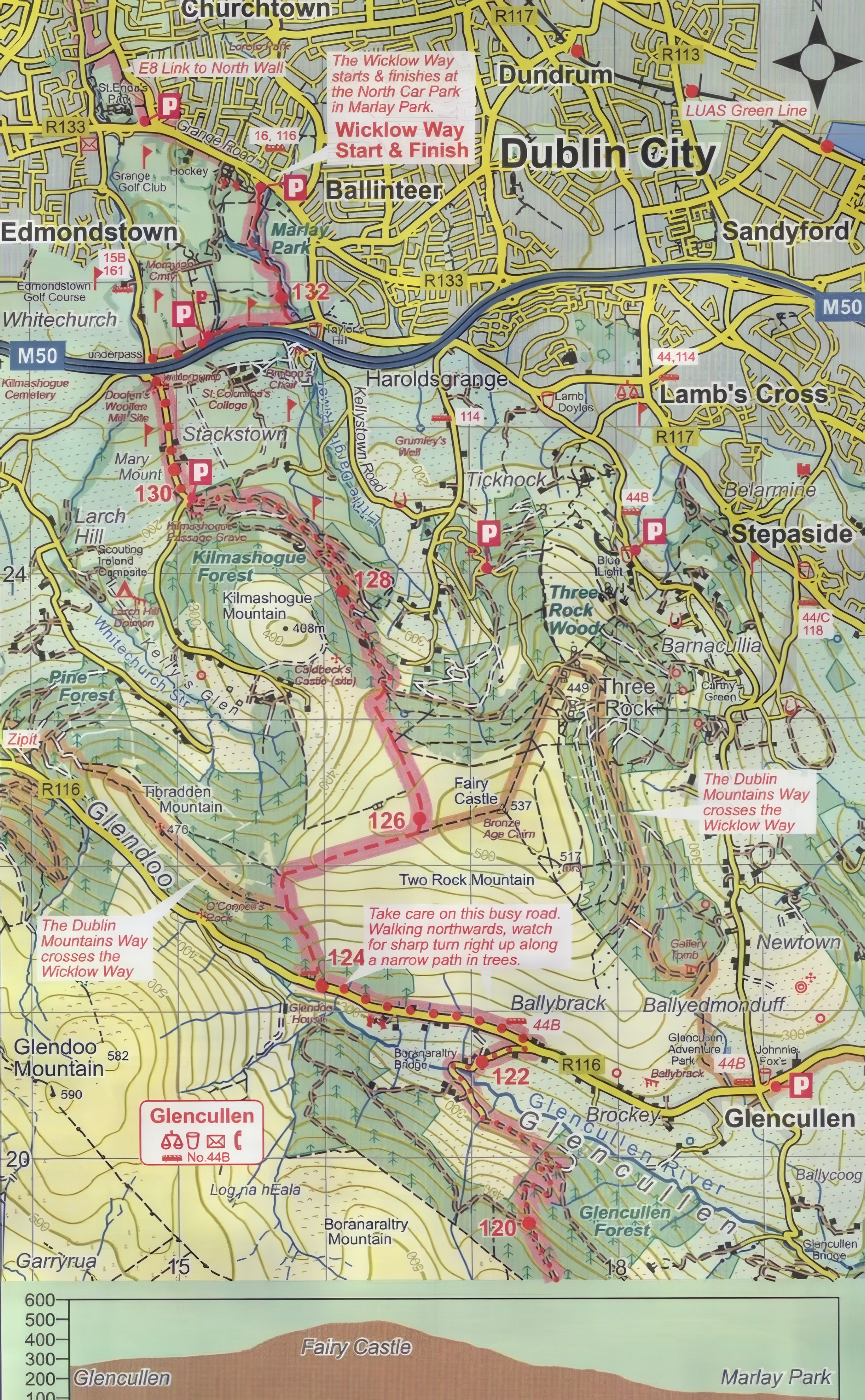
Marlay Park to Glencullen
Distance: 10km
Ascent: 230m
Walking Time: 3hrs
General Description:
The beginning of the trail leads down from the expansive Marlay Park to the forest trails of Glencullen.
- The Wicklow Way starts at the North car park near Marlay House and Craft Centre – if parking your car here, take careful note of the closing time which varies throughout the year.
- After a while, turning left from College Road through a tunnel under the M50 will lead you to the ascent to Fairy Castle – here you will find excellent views of Dublin Bay and the City as a whole.
- As you descend the summit you should take care on the busy road in Glencullen.
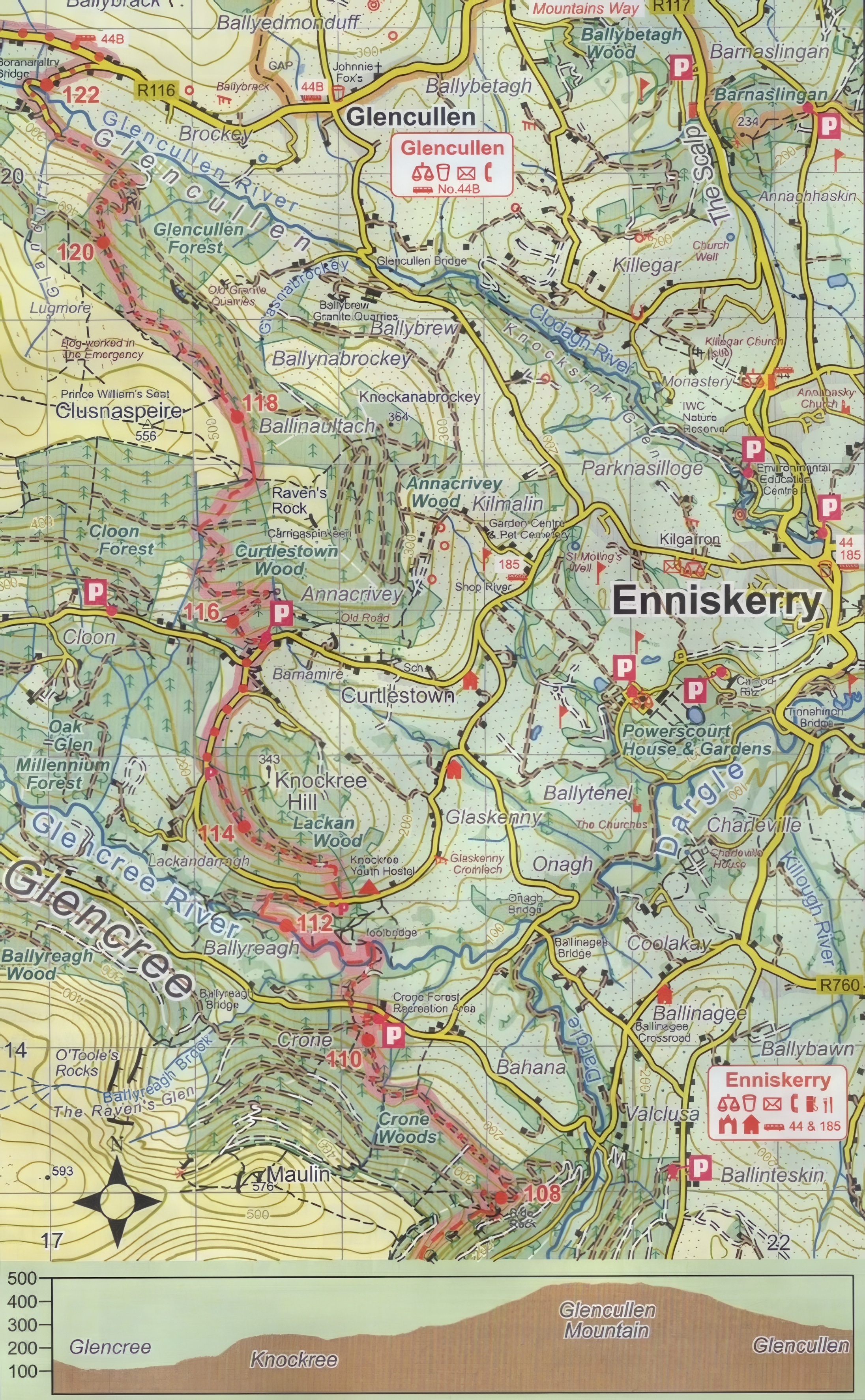
Glencullen to Glencree
Distance: 12km
Ascent: 420m
Walking Time: 4hrs
General Description:
Rising out of the forest roads of Glencullen, the Way continues by the shoulder of Ravens Rock and Curtlestown Wood. Good views of Bray Head and the Sugarloaf can be seen.
- The zig-zag trail of Glencullen forest reaches its end at the boggy track leading to the hillside.
- The Way exits Curtlestown forest just west of Ravens Rock.
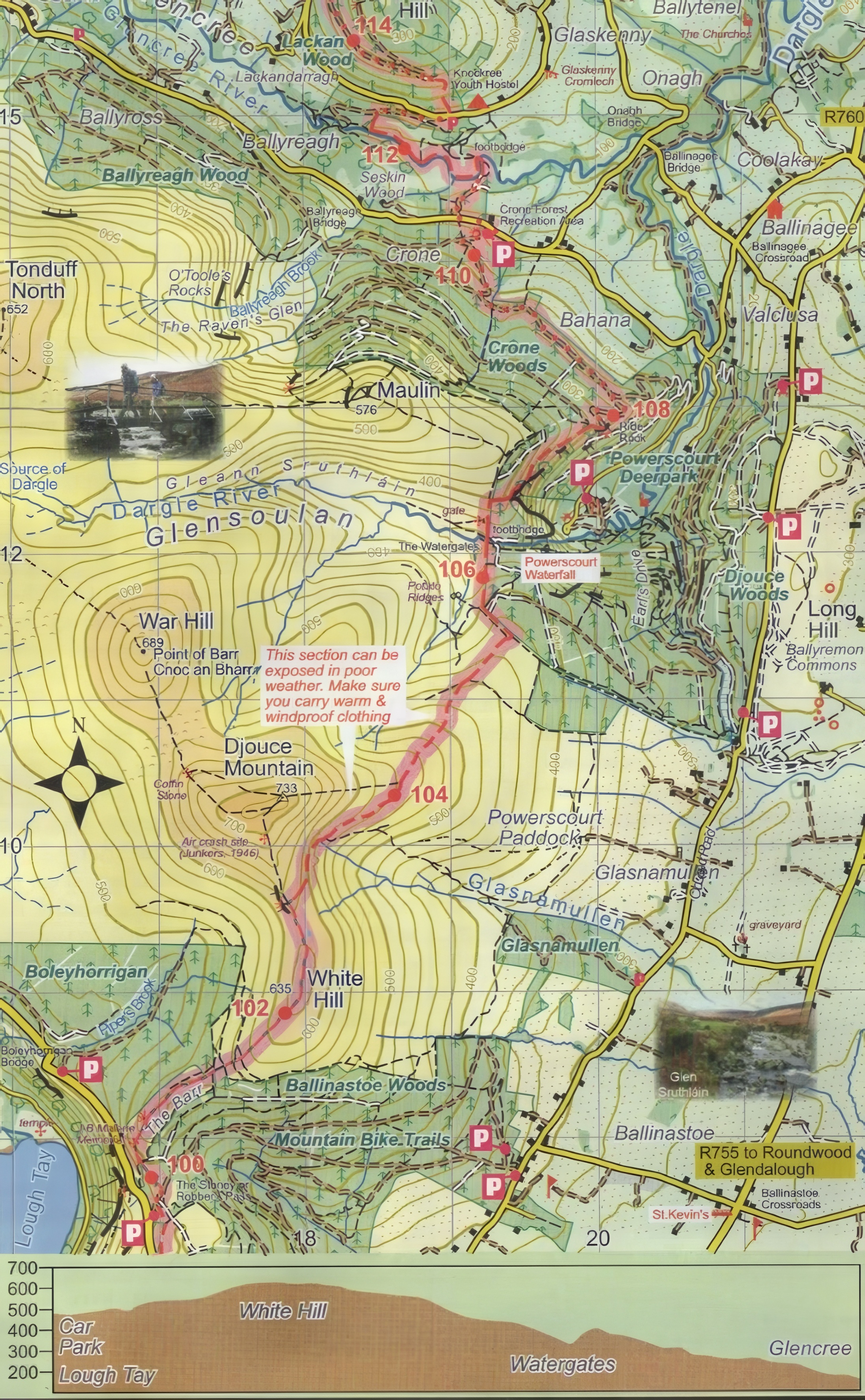
Glencree to Lough Tay
Distance: 12km
Ascent: 250m
Walking Time: 4hrs
General Description:
Climbing out of a wooded valley containing Powerscourt Waterfall, next comes a high open mountain trek across the shoulder of Djouce. Boardwalk tracks then lead to White Hill and then The Barr. The section of Djouce is high and exposed to bad weather. It can also be wet and boggy underfoot.
- On the road beside Knockree Youth hostel, you will find a riverside path and footbridge. Turn right from the forest path onto the public road, then left into Crone Car Park.
- Follow the twisting forest path and turn to lead downhill. You will eventually reach the footbridge at the Watergates, one of the older entrances to the Powerscourt Estate.
- Carry on down White Hill, using the boardwalk where available to avoid erosion of the mountain blanket bog.
- Follow the boardwalk along and note the spectacular views and the J.B. Malone memorial.
- At the end of the boardwalk, you will have arrived in Lough Tay Car Park.
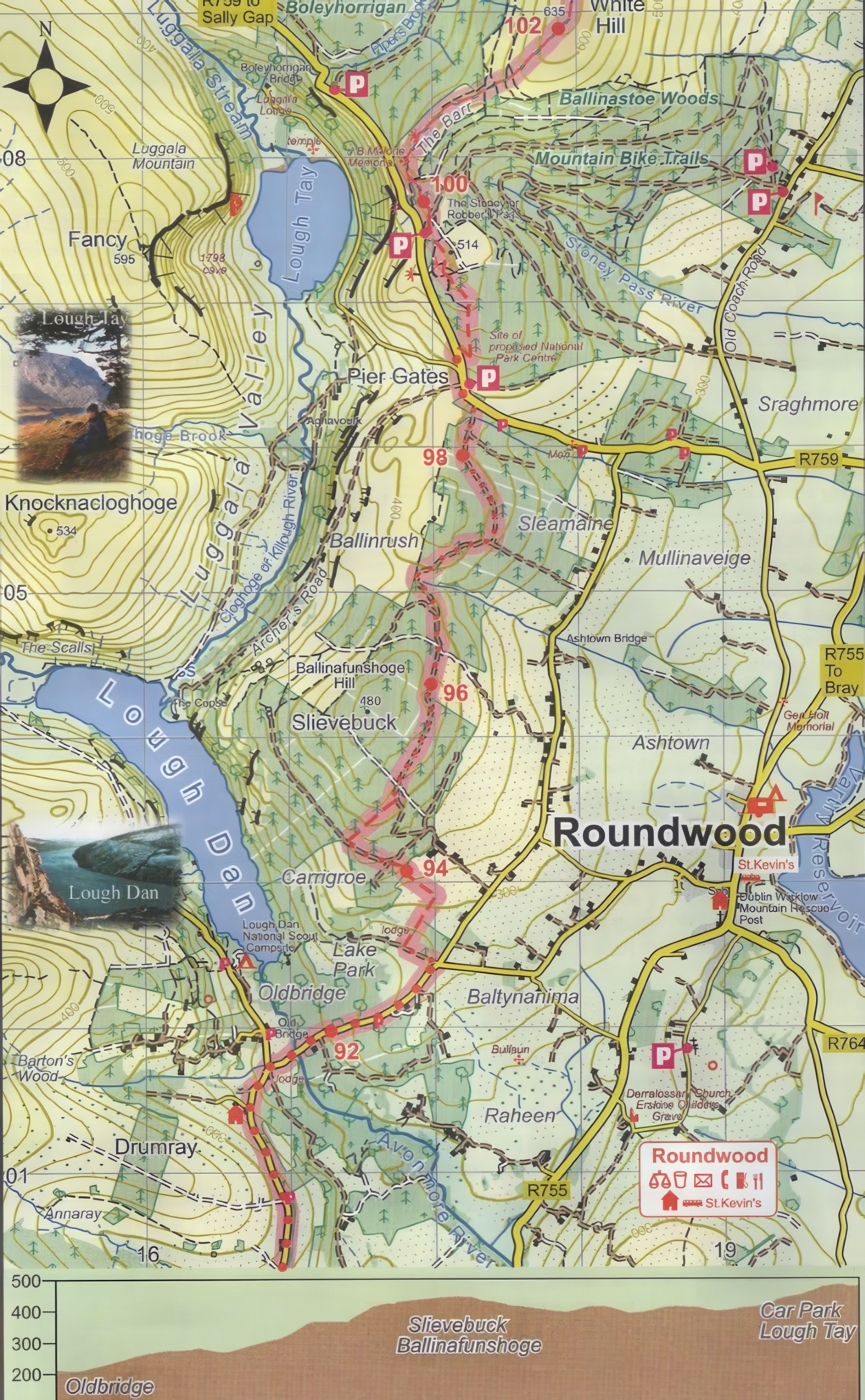
Lough Tay to Oldbridge
Distance: 6km
Ascent: 380m
Walking Time: 2hrs
General Description:
Forest paths continue from the Lough Tay Car Park. The path leads to a road near the Pier Gates, which in turn leads to a forested section over Ballinafunshoge Hill. This path eventually arrives at Oldbridge.
- Head out of the path from Lough Tay Car Park to find yourself in the forested roads that traverse Ballinafunshoge Hill.
- Turn right down hill to reach a forest corner with a fine view point of Lough Dan.
- From the forest, turn right to access the field paths, and soon you will arrive at the Oldbridge Crossroads.
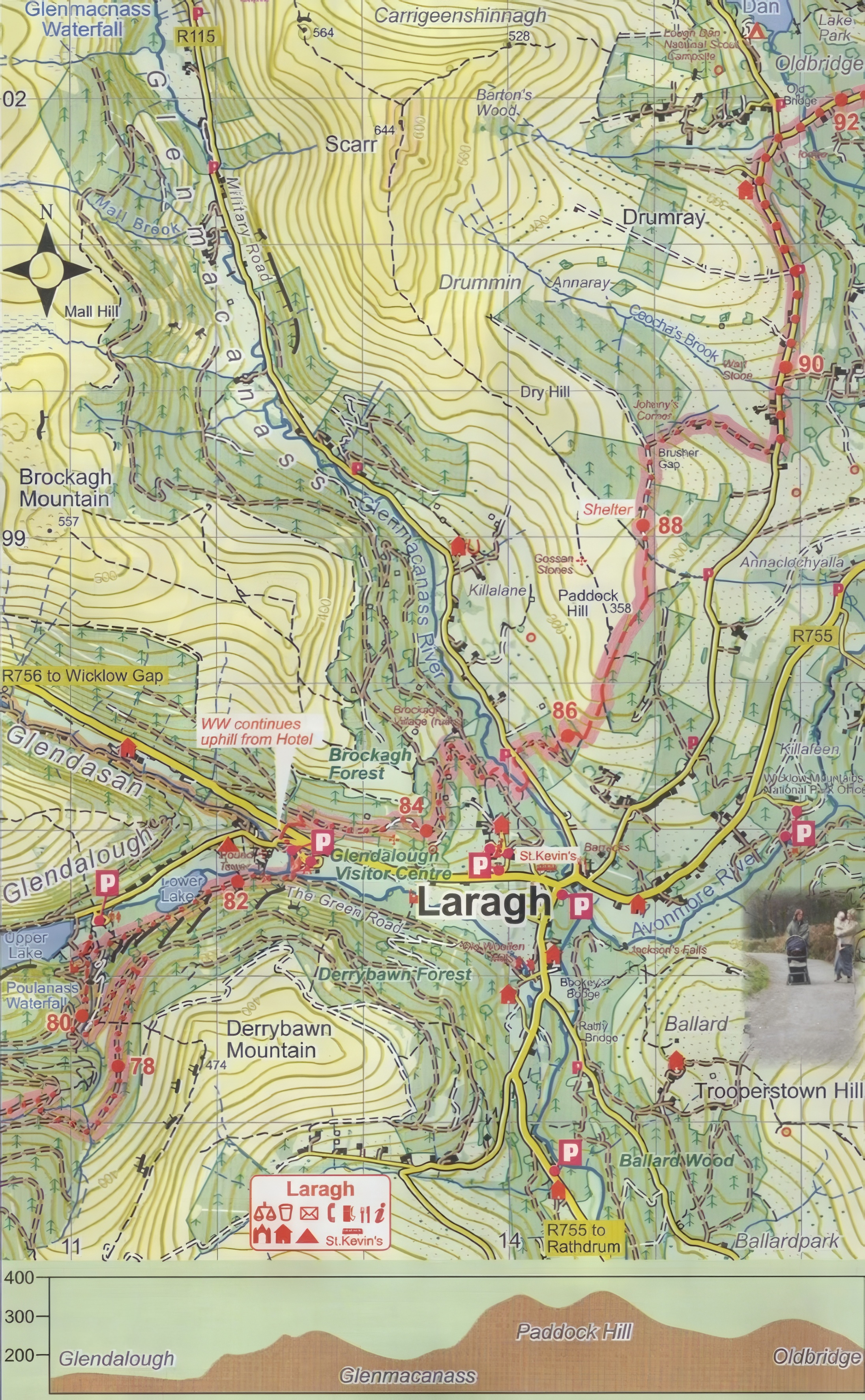
Oldbridge to Glendalough
Distance: 10km
Ascent: 440m
Walking Time: 3.5hrs
General Description:
From Oldbridge, the Way ascends to Paddock Hill, after which comes a short but sharp decline. The shoulder of Brockagh Mountain must be passed with an ascent from Glenmacanass.
- From Oldbridge, follow along the tarmac road that soon leads to a dirt one – you’ll arrive at the Brusher Gap, where the path leads uphill.
- Reach a forest corner and an overnight shelter.
- Paths now take you sharply downhill to the open land of Paddock Hill where there are extensive views.
- This leads to a road which will take you to the footbridge at Glenmacanass – cross it and continue along the riverbank paths.
- In Brockagh forest, a series of forest roads and tracks lead down to a busy road which must be crossed with care.
- The Way then takes a narrow path downhill opposite the Glendalough Hotel.
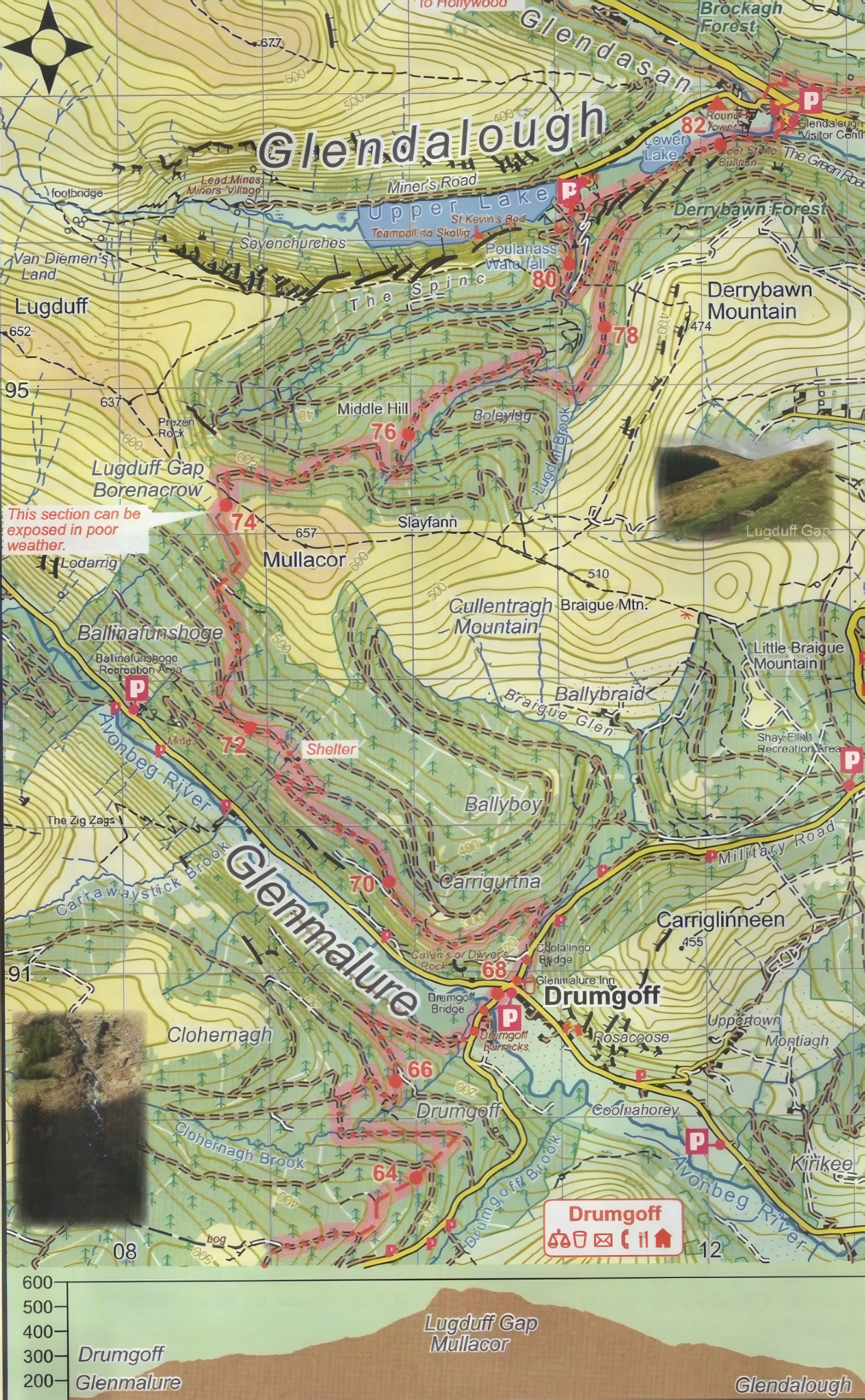
Glendalough to Glenmalure
Distance: 13km
Ascent: 520m
Walking Time: 4.5hrs
General Description:
A day of two halves, the first rises steadily out of the fine valley of Glendalough. On crossing Lugduff Gap, a long and steady descent of the Northern slopes of Glenmalure, with fine views of Lugnaquilla.
- By the waterfall of Poulanass, follow the riverside path as you ascend.
- Cross the boardwalk to get past the Lugduff Gap, then descend through the forest on a rough path.
- Continue on along through the forestry and you will come to the Glenmalure Inn.
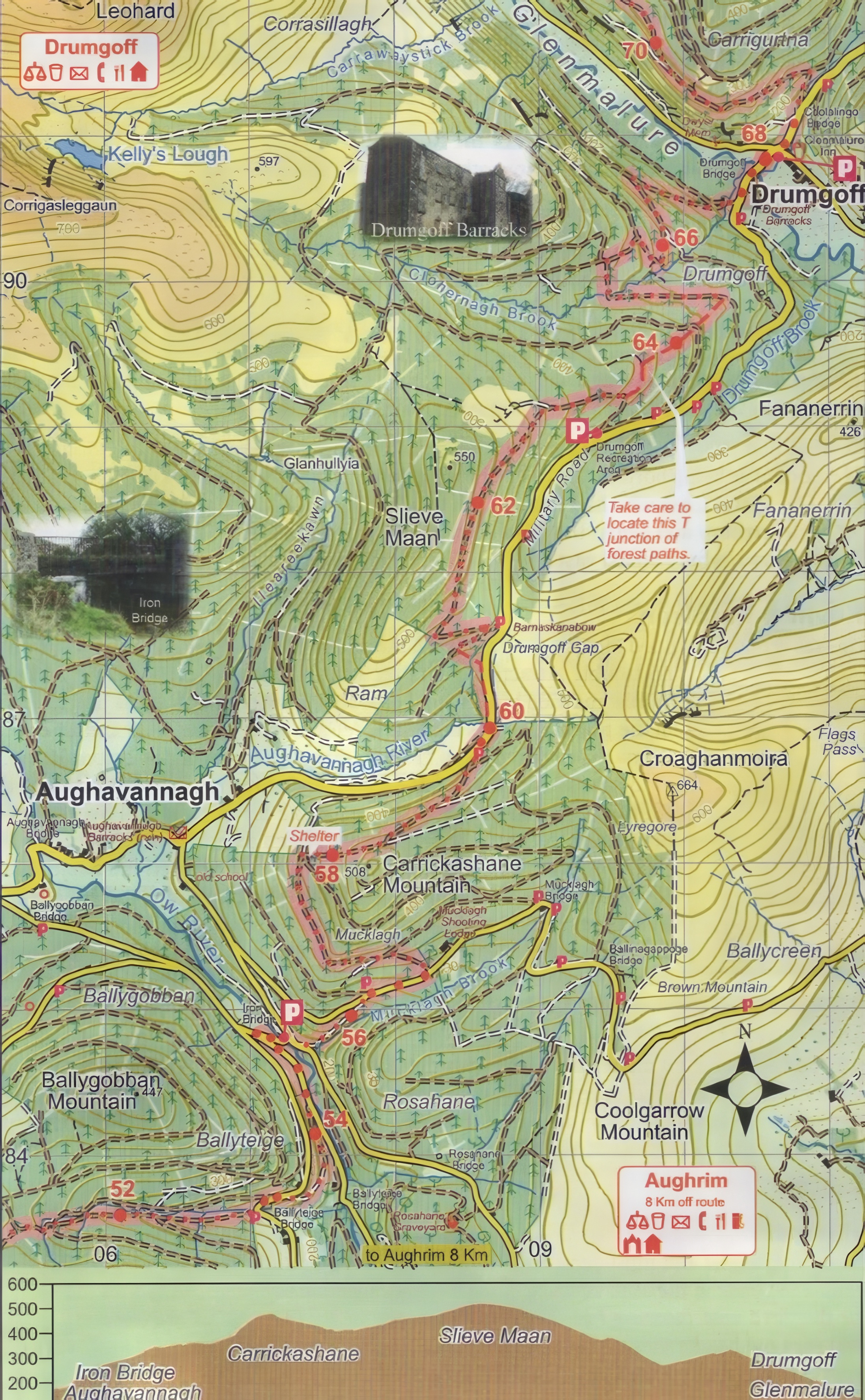
Glenmalure to Aughavannagh
Distance: 12km
Ascent: 500m
Walking Time: 4hrs
General Description:
The nature of the Way changes here. Instead of steep valleys and forests, the Way is now mainly on roads and trails meandering around low hills.
- Watch for a turn that ascends to Drumgoff.
- From there follow a trail that goes into a forest around Slieve Maan and cross to Drumgoff Gap.
- Bypass Carrickashane Mountain by heading down the downhill path.
- Reach a sleeping shelter on the forest corner.
- The Way now descends from Mucklagh Forest to reach the Iron Bridge.
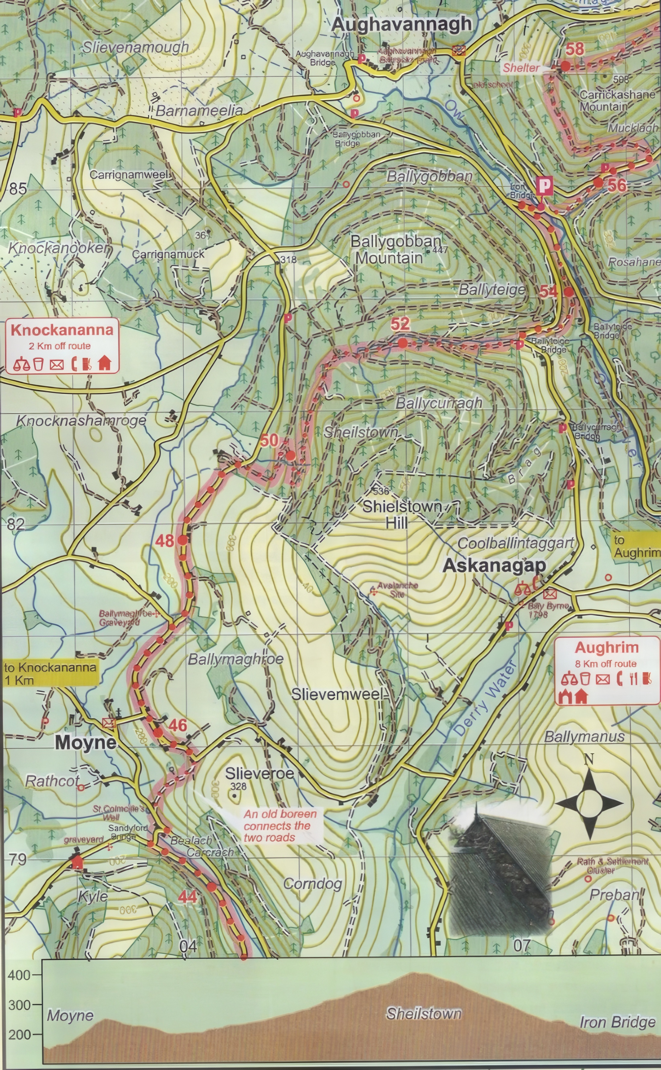
Aughavannagh to Moyne
Distance: 10km
Ascent: 300m
Walking Time: 3hrs
General Description:
The Way climbs down from conifer woods to minor roads.
- Coming out of Aughavannagh, you’ll find yourself in more forest trails.
- Cross the hill to get the wooded river valley of the Ow river, then continue on more trails leading out of the forest.
- You will journey along a grassy track for 4km before reaching two tarmac roads.
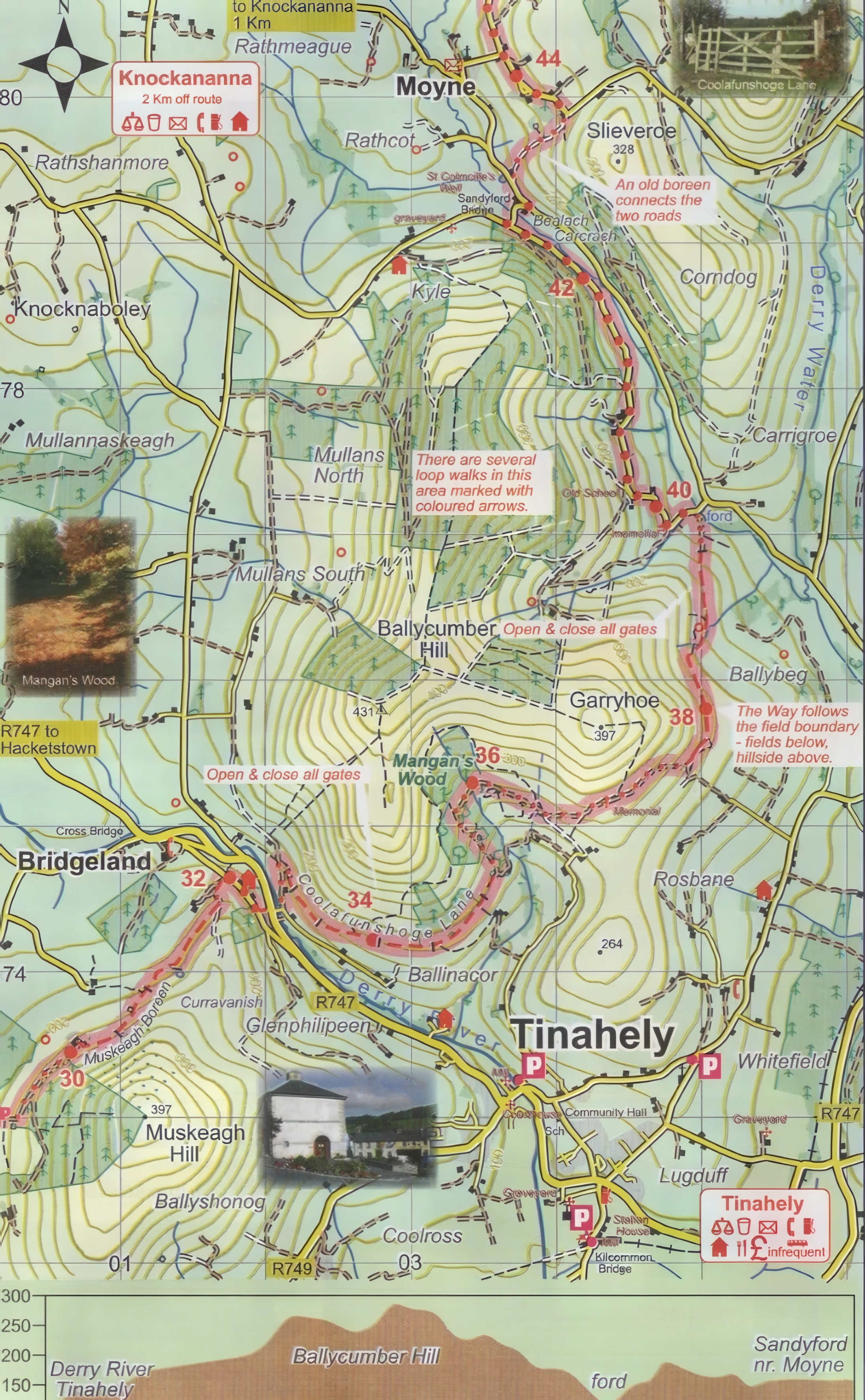
Moyne to Tinahely
Distance: 11km
Ascent: 300m
Walking Time: 3hrs
General Description:
This section is mostly on grassy tracks and old lanes with a short stretch of beech woodlands.
- Climb down the narrow roads to reach a ford on a stream.
- The way continues as a grassy path following the upper side of the field division.
- Cross the tracks at the shooting accident memorial.
- Walk through Mangan’s woods and reach Coolafunshoge Lane, a grassy track around the hill – take caution as the ground can be very wet here.
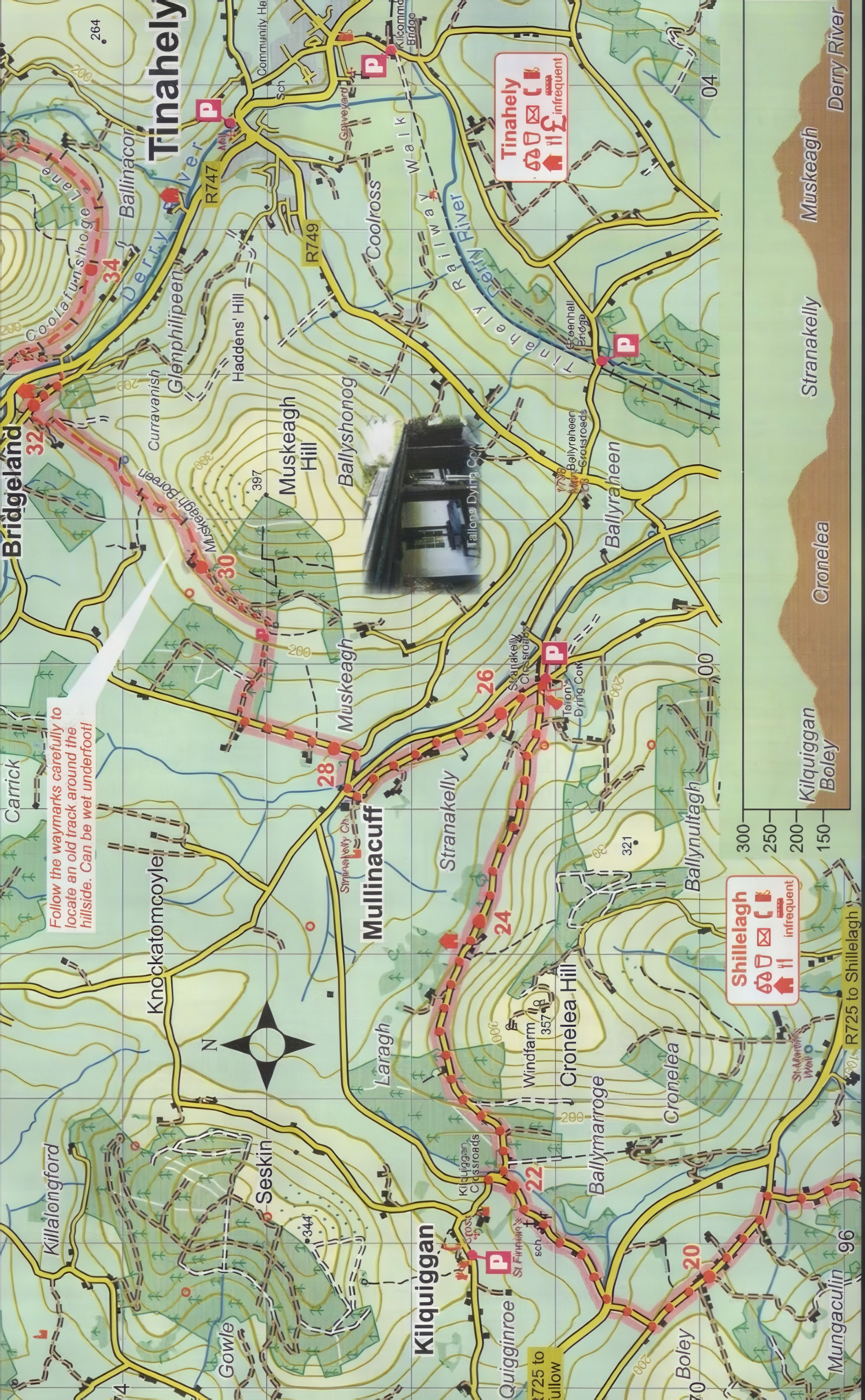
Tinahely to Boley
Distance: 12km
Ascent: 250m
Walking Time: 3+hrs
General Description:
This section of the Way commences on country roads with mild excursions into forests and low hills, before ending on a roadway.
- From the road, gain access to the farm tracks and follow it around Muskeagh Hill.
- Exit from Muskeagh boreen to the downhill road.
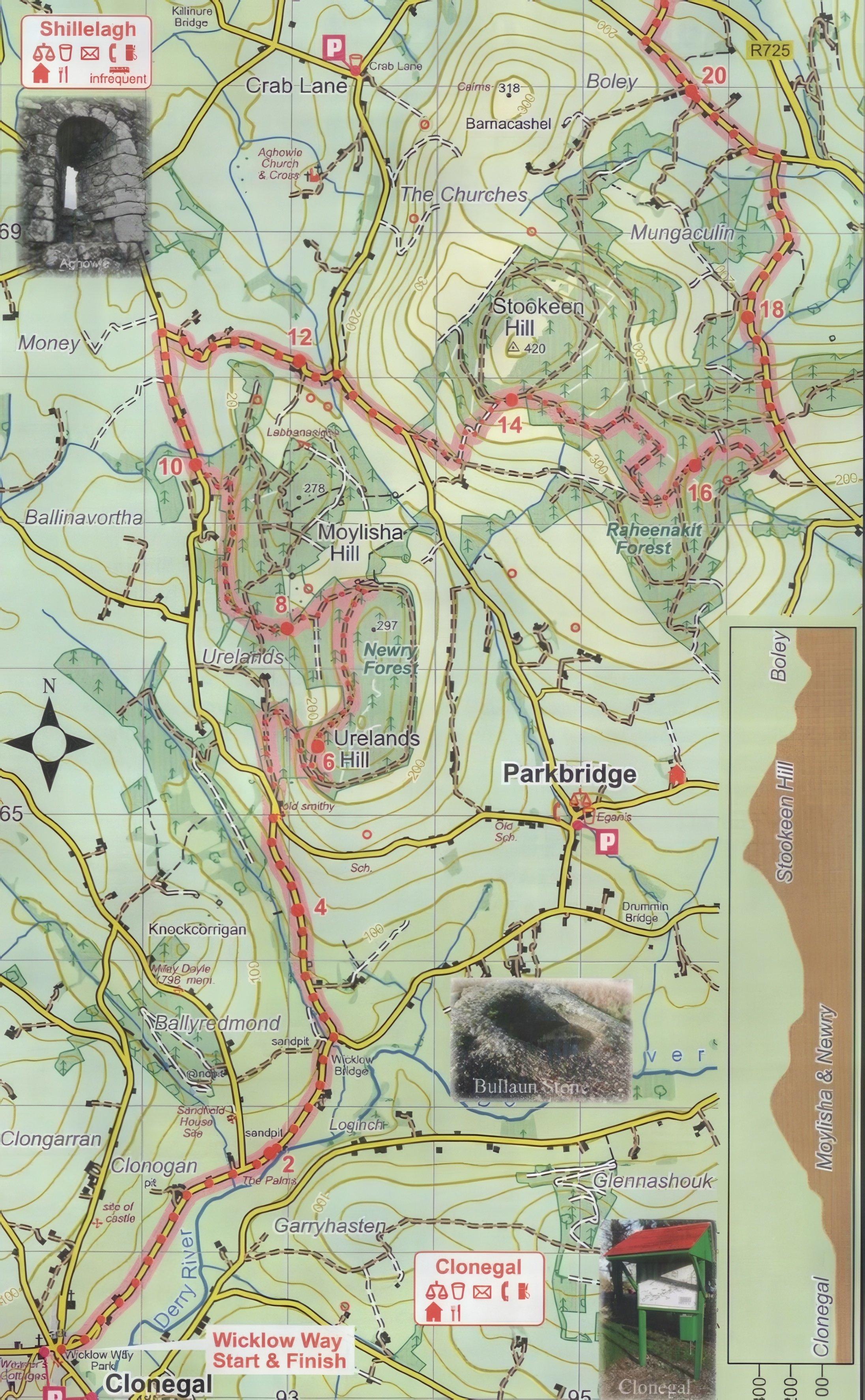
Boley to Clonegal
Distance: 20km
Ascent: 500m
Walking Time: 6hrs
General Description:
The Way follows a mixture of minor public roads and forest tracks here.
- Descend from Raheenakit forest. Watch for the sharp turns as you enter and exit Newry forest and end up on the tarred road.
- Follow the level road until you reach Wicklow Way park in Clonegal.